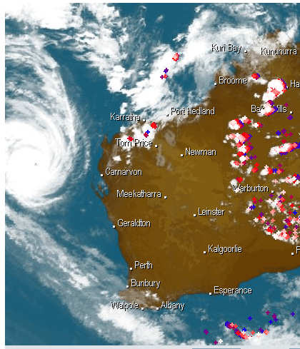
This is the satellite photo from 2:30 pm this afternoon (Jan 28, 2011), showing Cyclone Bianca. She turned the corner (NW Cape) dumping rain etc. on Onslow and Exmouth last night. Now she’s off the west coast. There’s a strong chance she will cross the coast on Sunday, with heavy rain and very strong winds, somewhere around Bunbury. We live somewhere near Bunbury… We’re on cyclone watch now.

The unusual thing is that tropical cyclones typically don’t come too far south at this time of the year — they tend to stay in the Kimberley or Pilbara, crossing the coast there then petering out into a tropical depression over the inland areas, dumping rain on places like Kalgoorlie and Esperance. Later in the season (about March/April) they tend to track further south, though they’re rarely a cyclone by the time they reach the Perth area. Exception: Cyclone Alby in (April?) 1978 that wrecked homes in a swathe from Bunbury to Albany.
Of course, this cyclone may peter out, or just fade off into the Indian Ocean. Or collect more power, water and force and come screaming down the coast…
It’s time to get the outdoor setting into the shed, find the battery-operated radio, etc.
Oh, for my non-Aussie friends, to give you some idea of the size of this thing, the section you can see on the map is most of Western Australia and Texas would fit into it about four or five times over (depending on who you ask)!
Update: Satellite image from 3:30 am 29 Jan, 2011. That area of pink/red north of Perth is about to hit us now — 6:15 am. Sky has gone black, rain hasn’t started yet, but imminent. Thunder rolling… Oops. Rain just started. Very heavy rain — can’t see the estuary or the sand dunes in the distance as we normally can. And did I mention it’s hot? 28C in the house at 6:00 am.

Update 7:15 am 30 January 2011: Well, it looks like all we’ll get is some strong winds and some rain, thank goodness. The 5:30 am satellite image (below) shows that the main part of the cyclone has weakened considerably, so if/when it does hit the coast, it will bring rain and some winds. We’ve had very little of both so far, though areas to the north of Perth (Geraldton) and to the east of Perth (Northam, York) copped a fierce battering in that storm you can see in yesterdays’ photo — the big white blob with red and blue blotches between Perth and Geraldton. That one missed us totally and went inland following the other red blotchy bits. There are still plenty of warnings out for coastal areas though, as along with the wind and rain, there are also some pretty high tides.

See also:
- History of cyclones hitting in/near Perth: http://www.bom.gov.au/cyclone/history/wa/perth.shtml

